TND bridges environmental science, spatial intelligence, and
civic technology — delivering authoritative GIS, environmental compliance, and the Callitin community
platform across Africa.
GIS+
Geospatial intelligence
EIA/BAR
Environmental authorisation
1 app
Callitin civic platform
Pan-Africa
Continental vision
What we do
Integrated expertise. Measurable outcomes.
We combine regulated environmental consulting, geospatial
science, and technology products under one operational entity.
Environmental consulting
EIAs, Basic Assessments, Environmental Management Programmes, and Water Use Licence
Applications with EAPASA-registered practitioners.
NEMA · NWA compliant
GIS & remote sensing
Professional mapping, satellite imagery, NDVI/NDWI monitoring, drone surveys, and
geodatabase development.
ArcGIS · QGIS · GEE
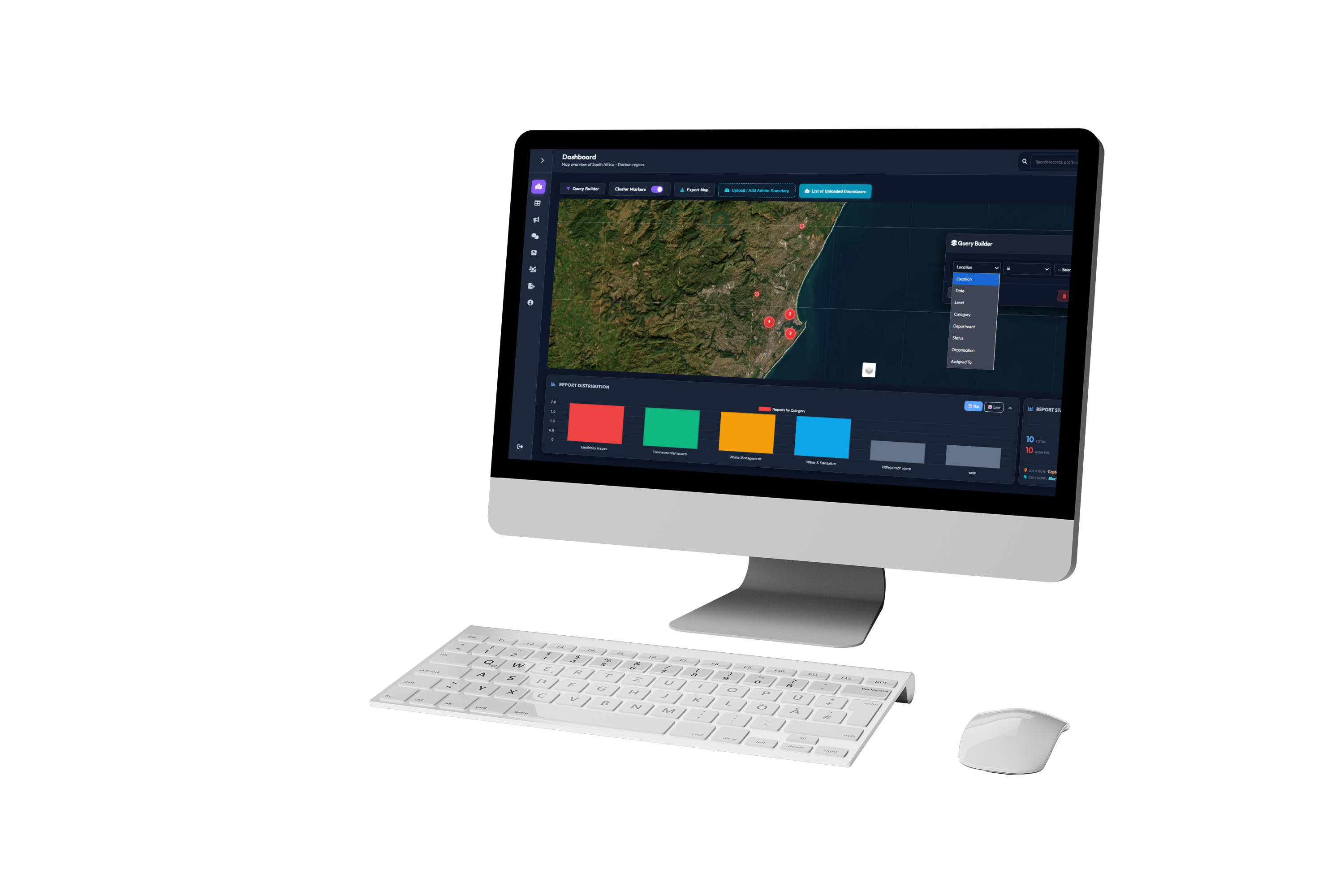
Geospatial dashboards
Custom interactive web dashboards that turn complex spatial and environmental datasets
into clear decision-support tools.
Power BI · Tableau · Custom
Compliance monitoring
Ongoing monitoring, air quality analysis, compliance auditing, and regulatory reporting
across construction and operational phases.
EMP · Audit · Reporting
Field data collection
GPS capture, site assessments, survey design, ground-truthing of remote sensing
findings, and quality-assured data processing.
Survey · UAV · Fieldwork
Urban & disaster risk
Settlement growth analysis, flood and wildfire risk mapping, agricultural suitability,
and smart city modelling.
Municipal · AgriTech · DRM
★ Flagship product
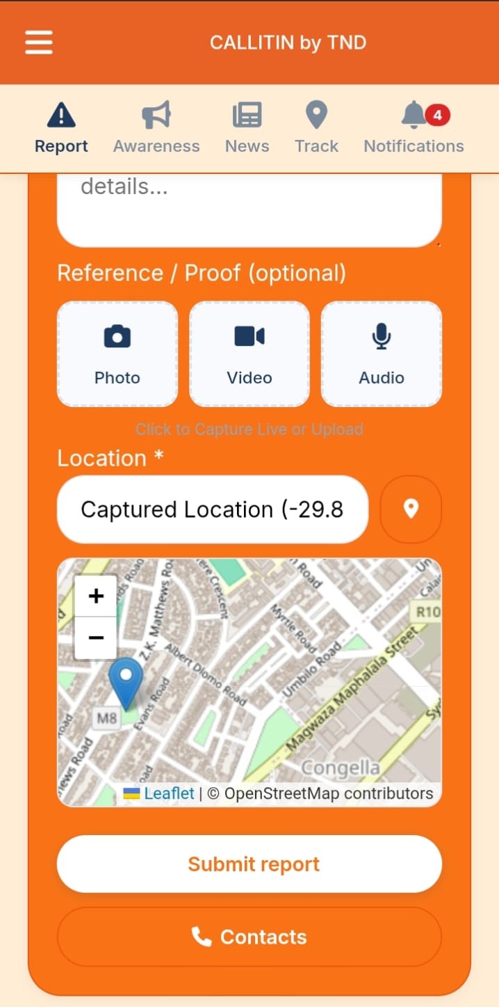
Meet Callitin. One app. Every report.
South Africa has hundreds of hotlines and fragmented channels
for community issues. Callitin replaces all of that with a single universal reporting platform — connecting
citizens directly to the organisations that can act.
Report with photos, video, and precise GPS location
Issues routed to municipalities, SPCA, neighbourhood watches, fire services
Interactive map showing all active reports in your area
Real-time status updates from submission to resolution
Organisation dashboards with analytics and case management
POPIA-compliant, governed by South African law
How we work
From data to decision.
01
Collect
Satellite imagery, drone surveys, GPS field capture, and
community-reported data feed into a single spatial intelligence layer.
02
Analyse
GIS analysis, remote sensing indices, environmental assessment,
and regulatory mapping extract meaning from raw spatial data.
03
Report
Legally compliant EIAs, BARs, EMPs, and WULAs alongside
interactive dashboards and real-time platform outputs.
04
Act
Actionable spatial intelligence reaches municipalities,
developers, NGOs, and communities — driving real decisions.
Who we serve
Across sectors. Across the continent.
Government & municipalities
Environmental authorisation, service delivery mapping, infrastructure planning, and
community reporting for public institutions.
Property & infrastructure
EIAs, BARs, and spatial compliance support for developers, engineering firms, and large
infrastructure projects.
Agriculture
Crop health monitoring, irrigation planning, yield prediction, and precision farm
mapping via satellite remote sensing.
Mining & energy
Environmental compliance, monitoring programmes, rehabilitation tracking, and spatial
risk assessments.
NGOs & conservation
Biodiversity monitoring, wildlife corridor analysis, climate research, and sustainable
development mapping.
Research & academia
Field data collection, GIS support, monitoring and evaluation infrastructure for
research institutions.
Ready to work with us?
Intelligence
that moves Africa forward.
Whether you need environmental
authorisation, geospatial analysis, or want to deploy Callitin for your organisation — let's talk.
Our partners
Trusted by those who lead.
We collaborate with registered practitioners, institutions, and
organisations that share our commitment to quality, compliance, and impact.
TerraLink Nova Developments
Our work. In the field & on screen.
Maps, assessments, dashboards, and field studies from across KwaZulu-Natal and
beyond. All work is protected — viewing only.
Filter:
TerraLink Nova Developments
Portfolio
GIS · Remote Sensing · Civic Technology KwaZulu-Natal, South Africa
Case Study · Ward 101, Cato Crest
A Joint Spatial Intelligence Briefing
From Pollution to Opportunity
Mapping illegal dumping and river health in Cato Crest, Ward 101 — a partnership
between TerraLink Nova Developments and Inhlanzeko Environmental Solutions (IES).
Location Cato Crest, Durban, KZNPartner Inhlanzeko Environmental SolutionsStatus Baseline & model test complete
66
georeferenced illegal dumping points mapped
2,159.94 m
of river running directly through contaminated corridors
Who's in the Room
Two organisations, one ward
Illegal dumping isn't an isolated problem — it's the trigger point for
compounding risk across Ward 101. No single organisation can solve it alone, which is why this work
pairs spatial evidence with on-the-ground community action.
Spatial intelligence
TerraLink Nova Developments
GIS, remote sensing & spatial modelling. TND turns satellite data, drone surveys, and field GIS
into spatial models that show municipalities and communities exactly where environmental risk is
concentrated — and why.
Community & on-the-ground action
Inhlanzeko Environmental Solutions
IES works directly with the Cato Crest community — leading local engagement and environmental
clean-up action, including plans for a community plastic buy-back centre.
Why This Matters
Seven compounding risks, one trigger point
Illegal DumpingPublic Health RiskRiver PollutionEnvironmental DegradationFlood RiskCommunity SafetyClimate ResilienceSDG Alignment
Why the Partnership Matters
One framework connecting every variable
Land use, settlements, rivers, infrastructure, and waste systems are all
connected — so the response has to be too. GIS & remote sensing is the single framework tying
every variable into one picture of risk. We're building a repeatable spatial intelligence model — not
simply producing another report.
Why this matters→What we found→How the model works→Where it's headed
The Full Deck
TND × IES briefing — Cato Crest, Ward 101
Presented at the Cato Crest Capacity Building Workshop. Click any slide to view
it full-size.
What We Found
66 sites. One river. A clear pattern.
Illegal dumping hotspots correlate directly with river contamination — wherever
dumping clusters, water quality measurably degrades downstream. Because the pattern repeats spatially,
it can be modelled and resources can be targeted to the exact corridors driving the most
contamination.
Field site, Cato Crest watercourse — solid waste accumulation at the water's edge
We didn't just map it from
orbit — we tested it on site
🧪
E.coli & faecal coliforms
Indicators of sewage contamination
⚗️
pH
Acidity / alkalinity of river water
〜
Turbidity
Water clarity / suspended solids
📍
Ground-truthing (TND)
Physical site visits by TND confirming every mapped point
💬
Citizen observations
Local reports of dumping and water condition
Photo Evidence
What this looks like on the ground
Beyond Cato Crest, the same pattern of uncollected waste and blocked
watercourses repeats across the wider municipal area — the mechanism the spatial model is built to
predict.
Uncollected waste accumulating at a roadside dumping site
Waste choking a stormwater culvert and watercourse beneath informal housing — the
exact mechanism linking dumping to flood risk
Our Methodology
A repeatable model, not a one-off report
Four phases take this from a single ward pilot to a standing regional
capability.
01
Baseline
Map current conditions — dumping sites, river health, land use — to establish ground truth for Ward
101.
Complete
02
Model Build
Combine the baseline data with elevation, drainage, rainfall, and land use layers in ArcGIS Pro to
build a waste-risk and flood-risk surface for the ward.
Built
03
Validation
Check the model's predicted risk surface against the 66 mapped dumping sites and field results —
does it correctly flag where contamination already concentrates?
In progress
04
The Network
Expand the partner network — more organisations like IES, more wards — scaling one proven method
city-wide.
Next
How the Model Works
A predictive model, built in ArcGIS Pro
This isn't just a map of what we found — it's a model of where the next problem
is likely to happen. We combine the Phase 1 baseline data with terrain, drainage, rainfall, and
land-use information to produce a single risk surface across Ward 101, then run flood simulations
against the same terrain to see where water actually moves.
Inputs
Baseline data — 66 mapped dumping sites &
field results
Elevation & terrain (where water naturally
collects)
Drainage network & infrastructure
Rainfall data
Land use & settlement patterns
→
Processing — ArcGIS Pro
Layers combined into one spatial model
Flood simulations run against the terrain
Waste-risk & flood-risk scored
together
→
Output
A combined risk surface for Ward
101 — showing where waste accumulation and flood exposure are likely to compound
Variable category
Drives waste risk
Drives flood risk
Physical / Environmental
Land use, slope, river proximity
Elevation, runoff & low-lying accumulation zones
Infrastructure
Drainage, waste collection, road access
Drain blockage & flood pathways
Social
Settlement density, informal housing
Population exposure to flooding
Where this stands: the combined risk model is built. The next step is validation —
checking the model's predicted hotspots against the 66 dumping sites and field results from Phase 1, to
confirm it flags real-world risk accurately before it's used to guide municipal action.
The link in practice: a stormwater culvert choked with dumped
waste beneath informal housing — exactly the infrastructure pathway the model flags as both a waste
hotspot and a flood risk.
Making Data Useful
Reports are a snapshot. Dashboards make it live.
A shared stakeholder dashboard — municipality, IES, and community groups seeing
the same live map, updated automatically as new mapping rounds complete, filterable by ward, pollution
type, or severity. Built on free, lightweight tools, not locked behind expensive licences.
1 · Community reporting & satellite mapping→2 · Feeds the shared dashboard→3 · Guides municipal action→4 · New mapping confirms impact
On the Ground
The Cato Crest Capacity Building Workshop
TND presenting pollution mapping findings for Ward 101 at the Cato Crest
Capacity Building Workshop, in partnership with KZN EDTEA and eThekwini Municipality.
What the Findings Mean
This is not a coincidence
Internal notes on the read-through of the evidence and where the partnership
goes next.
Pattern
Same root cause
Dumping and contamination both trace back to the same underlying gaps — incomplete waste collection
coverage and ageing infrastructure, not isolated bad behaviour.
Implication
A predictable, mappable pattern
Because the pattern repeats spatially, it can be modelled and predicted — resources can be targeted
to the exact corridors driving the most contamination, instead of spread evenly across the ward.
Correlation
Dumping hotspots ↔ river contamination
Wherever dumping clusters, water quality measurably degrades downstream of it — confirmed by
on-site water quality screening, not just the satellite layer.
Open question
Dashboard cadence
Define how often mapping rounds repeat once the shared dashboard is live, and confirm TND's
schedule for the next ground-truthing pass.
Looking Ahead
From mapping to momentum
This data already supports two next steps now underway.
Community-led
A Plastic Buy-Back Centre
The plastic waste mapped in this study is exactly what a community buy-back centre would intercept
before it reaches the river. IES is pursuing approval for a centre where Cato Crest residents can
sell plastic bottles directly — turning today's evidence into tomorrow's local income.
Led by IES · Supported by TND's spatial evidence
In development
Introducing Callitin
An integrated communication platform designed to strengthen collaboration between communities,
municipalities, and environmental stakeholders.
More details to come — watch this space
Geospatial Intelligence
Maps. Analysis. Decisions.
TND's GIS and remote sensing capabilities are a core technical
competency — supporting environmental consulting, standalone client projects, and technology product
development across South Africa.
ArcGIS
Primary platform
GEE+
Cloud remote sensing
UAV/SAR
Multi-source data
GISSA*
Registered partners
What we offer
Geospatial solutions built for Africa.
GIS work is conducted in partnership with GISSA-registered
practitioners where professional registration is required, ensuring legally compliant and professionally
certified spatial outputs.
Spatial Data Collection
GPS field surveys, drone and satellite-derived data capture, and integration of
third-party spatial datasets. All data is validated and quality-assured before delivery or incorporation
into GIS databases.
GPS · Drone · Satellite
GIS Mapping & Cartography
Professional maps for land-use and zoning, environmental sensitivity and constraint
analysis, infrastructure and asset management, community development, and EIA/BAR regulatory submissions.
Produced in ArcGIS Pro and QGIS.
ArcGIS Pro · QGIS
Spatial Analysis
Overlay analysis, buffer analysis, network and route optimisation, site suitability
assessments, land use change detection, and gap analysis identifying deficiencies in service delivery or
infrastructure coverage.
Analysis · Modelling · Suitability
Remote Sensing
Satellite imagery analysis using Sentinel-1 SAR, Sentinel-2 multispectral, Landsat,
MODIS, and drone-derived orthomosaics. Applications include land cover classification, vegetation
monitoring, deforestation detection, flood mapping, and rehabilitation verification.
Sentinel · Landsat · GEE
Drone & UAV Surveys
UAV deployments for high-resolution orthomosaics, digital elevation models, and point
cloud datasets. Suitable for site assessments, rehabilitation monitoring, topographic mapping, and
infrastructure inspection.
UAV · DEM · Orthomosaic
Geodatabase Development
Design and management of centralised geospatial databases, environmental information
systems, and spatial data management systems on PostGIS and PostgreSQL. Structured spatial repositories for
organisations needing integrated location data.
PostGIS · PostgreSQL · Geodatabase
Geospatial Dashboards
Custom web-based dashboards transforming complex spatial and environmental datasets into
accessible decision-support tools. Built on ArcGIS Online, Power BI, Tableau, and custom web development
frameworks including Leaflet and Mapbox.
ArcGIS Online · Power BI · Leaflet
NDVI & NDWI Monitoring
Normalised Difference Vegetation Index monitoring for vegetation health and
rehabilitation tracking. NDWI analysis for surface water extent, wetland delineation, drought monitoring,
and water body change detection.
Vegetation · Water · Indices
Urban & Disaster Risk Modelling
Settlement growth and urban expansion analysis, infrastructure planning, service
delivery gap mapping, flood and wildfire risk assessment, watershed mapping, and climate change impact
analysis including Urban Heat Island studies.
Urban · Risk · Climate
Technology stack
Tools of the trade.
A modern, professional-grade
technology stack applied across every project.
GIS
Platforms
ArcGIS Pro, ArcGIS Online, QGIS, Terrset, Google Earth Engine
Python, JavaScript, SQL, PostGIS, PostgreSQL, Leaflet, Mapbox, Google Maps API
VIZ
Visualisation
Power BI, Tableau, ArcGIS Online, custom web dashboards, story maps
Precision agriculture
Geospatial intelligence for the land.
TND develops precision agriculture
solutions leveraging satellite imagery and GIS to support farming operations and food security.
Crop health monitoring
Remote sensing indices tracking crop
condition, stress, and growth across seasons.
Farm boundary mapping
Precision GPS and satellite-based
delineation of farm parcels and zones.
Irrigation & water optimisation
Spatial analysis for irrigation
planning and water use efficiency.
Yield prediction & land assessment
Seasonal analysis, agricultural
suitability modelling, and soil erosion mapping.
Disaster risk management
Early warning. Every time.
Spatial systems and analytical
products to reduce the impact of floods, wildfires, droughts, storms, and landslides.
Hazard mapping & vulnerability assessment
Spatial models identifying flood,
fire, drought, and landslide exposure zones.
Climate change analysis
Carbon mapping, greenhouse gas
monitoring, Urban Heat Island analysis, and climate adaptation studies.
Emergency response planning
Evacuation route optimisation,
watershed mapping, and flood risk assessment.
Biodiversity & corridor analysis
Wildlife corridor mapping,
biodiversity hotspot identification, and conservation priority zoning.
Start a GIS project
Your data, mapped
with precision.
From a single map to a full
spatial intelligence system — let's scope your project.
Environmental Consulting
Compliant. Rigorous. Authorised.
TND's environmental consulting service line delivers formally
regulated outputs under NEMA and the National Water Act — carried out in partnership with EAPASA-registered
Environmental Assessment Practitioners.
EIA/BAR
Authorisation reports
EMP+
Management programmes
WULA*
Water use licensing
EAPASA✓
Registered partners
Regulatory framework
Built on South African law.
All formal environmental authorisation work is undertaken in full
compliance with applicable legislation and in partnership with EAPASA-registered practitioners.
NEMA
National Environmental Management Act
Primary legislation governing EIAs, Basic
Assessments, and environmental authorisation in South Africa.
NWA
National Water Act
Governing Water Use Licence Applications
for activities affecting watercourses, wetlands, and abstraction.
EAPASA
Registered Practitioners
All regulated EAP work is executed in
partnership with EAPASA-registered practitioners ensuring legal compliance.
DWS / DFFE
Competent Authorities
TND liaises with DFFE, provincial DEAs,
and DWS throughout authorisation and licensing processes.
Services in detail
Every phase. Every requirement.
From initial screening to post-construction compliance, TND
covers the full environmental authorisation lifecycle.
EIA
Environmental Impact Assessment
The full EIA process evaluates the potential environmental impacts of proposed developments or activities
before authorisation is granted by a competent authority. Required under NEMA for projects triggering
listed activities with significant potential impacts.
A simplified form of environmental assessment for projects triggering NEMA listed activities where impacts
are expected to be manageable. Faster turnaround than a full EIA but equally formal and legally required.
TND prepares all technical components, public participation documentation, and authority submissions.
A legally binding document developed alongside EIAs and BARs, forming a condition of Environmental
Authorisation. Defines how an approved project will be managed environmentally throughout construction and
operational phases.
Prepared under the National Water Act and submitted to the Department of Water
and Sanitation. Required where projects involve abstraction from a water resource, alteration of a
watercourse, or activities impacting wetlands. TND handles technical assessments, motivation reports, and
all DWS submission requirements.
Technical water use assessmentsMotivation reportsDWS submissionsSpecialist coordination
Ongoing services
Before, during, and after authorisation.
Environmental Screening
Preliminary screening to identify sensitive areas,
protected ecosystems, and potential constraints before committing to a formal authorisation process.
Establishes baseline environmental context.
Pre-application ·
Baseline
Air Quality Monitoring
Measurement and analysis of particulates, gases,
and pollutants relevant to industrial, mining, or construction activities. Supports regulatory reporting and
compliance verification.
Particulates · Gases ·
Reporting
Compliance Auditing
Evaluating whether operations meet environmental
authorisation conditions and applicable legal obligations. Includes site inspections, risk evaluations, and
compliance reports to regulators and municipalities.
Audit · Inspect ·
Report
Need environmental authorisation?
We'll get you
compliant, correctly.
Whether it's an EIA, BAR, EMP, or
WULA — TND handles the full process in partnership with registered practitioners.
About TerraLink Nova Developments
Where science, space, and impact meet.
TND is a South African technology and consulting company operating
at the intersection of environmental science, geospatial intelligence, and digital technology — delivering
integrated solutions to governments, municipalities, NGOs, and communities across Africa.
Vision
A leading African spatial authority.
To become a leading African authority in geospatial
intelligence, environmental compliance, land governance, and sustainable development — providing
technology-driven solutions that transform how communities, organisations, and institutions collect, report,
manage, and act on critical information.
Mission
Scalable solutions. Real impact.
To develop scalable,
technology-driven solutions that enable better reporting, stronger decision-making, efficient data
collection, and measurable social and operational impact.
→Democratise access to geospatial information across
Africa
→Build practical digital solutions for environmental,
civic, and operational challenges
→Integrate AI with spatial analytics and mapping platforms
→Support sustainable development through responsible
technology
→Make location intelligence accessible to individuals,
businesses, and institutions alike
Core principles
How we operate.
Innovation
Pursuing modern, technology-forward approaches rather than traditional methods alone —
applying the latest tools to every project.
Accountability
Taking ownership of all outputs and ensuring legal and professional compliance. Every
deliverable meets the standard required by regulation and our clients.
Accuracy
Maintaining high standards of data quality and analytical rigour. Spatial data is only
as valuable as it is correct.
Collaboration
Working with clients, partners, and registered EAPASA and GISSA practitioners to
deliver compliant and effective outcomes.
Community Impact
Ensuring that solutions create tangible benefit for communities and end users — not
just institutions and organisations.
Sustainability
Supporting development that balances economic growth with environmental protection and
responsible resource use.
Competitive differentiation
What makes TND different.
Multi disciplinary
Integrated model
TND uniquely combines environmental law, spatial science, civic technology, and digital
product development under one operational entity. Few comparable organisations operate across all four
domains.
Tech- led
Modern approach
While many consultancies rely on traditional methods, TND applies modern geospatial tools,
remote sensing, and digital platforms to deliver faster, more cost-effective, and more scalable results.
Afro- centric
Built for Africa
Solutions specifically designed for the South African regulatory environment and the
broader African development context — not imported frameworks from other jurisdictions.
Action- oriented
Beyond reporting
TND builds systems that connect reported information to visible operational action and
measurable outcomes — not just data collection and documentation.
Partnerships & Collaboration
Growing together, delivering more.
TND actively partners with businesses of all sizes — from
emerging SMEs to established enterprises — to extend the reach and impact of our geospatial and
environmental services. Whether you are looking to enhance your own service offering or need a capable
technical partner to fulfil a project component, we welcome the opportunity to collaborate.
We currently operate as subcontractors across a number of active projects, working
alongside companies and consultancies to deliver specialised GIS, remote sensing, and environmental outputs.
This model allows us to take on a high volume and diversity of work while enabling our partners to
confidently deliver on their client commitments.
Small & medium businesses
We work with smaller firms and start-ups
who need access to specialist geospatial or environmental capability without the overhead of an in-house
team. TND plugs in seamlessly as a technical partner.
Large corporates & consultancies
Established companies can leverage TND's
technical depth on large-scale projects — from multi-site environmental assessments to enterprise GIS
infrastructure — with the rigour and compliance standards their clients expect.
Subcontracting & joint ventures
TND is an experienced subcontractor. We
integrate into your project structures, meet your reporting timelines, and deliver technically sound
outputs — so you can focus on your client relationship while we handle the specialist work.
Interested in partnering with TND?
Reach out and let's explore how we can work
together to deliver more.
Problems we solve
Challenges TND was built for.
Poor spatial
information
Many organisations make planning and
compliance decisions without accurate, up-to-date spatial data. TND provides authoritative maps and
geospatial analysis.
Environmental
non-compliance
Regulatory requirements under NEMA and the
NWA are complex. TND helps organisations understand and meet their legal obligations.
Fragmented community
reporting
Citizens lack a unified channel to report
issues. The Callitin platform resolves this through a single universal interface for all service providers.
Data fragmentation
Organisational data is often siloed. TND
creates centralised geospatial databases that integrate information from multiple sources.
Poor decision-making
Without evidence-based spatial intelligence,
development and operational decisions are poorly informed. TND provides the analytical foundation for better
outcomes.
Service delivery
challenges
Spatial analysis identifies infrastructure
gaps and supports more effective allocation of public resources to where they are needed most.
Legal name
TerraLink Nova
Developments (Pty) Ltd
Company type
Private Company (Pty)
Ltd · South Africa
Professional bodies
EAPASA · GISSA · SAGC
Geography
KwaZulu-Natal ·
Pan-Africa vision
Our partners
Built on trusted collaboration.
TND works alongside registered practitioners, professional bodies,
and strategic partners to deliver compliant and effective outcomes across every project.
Get in touch
Let's build
something that matters.
Whether you're a municipality,
developer, NGO, or researcher — TND has the spatial and environmental capability to support your project.